


Col de Saint Sorlin - Belvédère du Mouflon iOS

i20
User
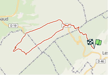

Length
10.7 km

Max alt
1225 m

Uphill gradient
337 m
Km-Effort
15.2 km

Min alt
1028 m

Downhill gradient
338 m
Boucle
Yes
Creation date :
2023-07-29 12:45:54.0
Updated on :
2023-07-29 15:06:54.883
2h20
Difficulty : Medium

FREE GPS app for hiking
 SityTrail
IGN / Geographical institutes
SityTrail Plus
The world is yours!
About
Trail Walking of 10.7 km to be discovered at Bourgogne-Franche-Comté, Doubs, Les Pontets. This trail is proposed by i20.
Positioning
Country:
France
Region :
Bourgogne-Franche-Comté
Department/Province :
Doubs
Municipality :
Les Pontets
Location:
Unknown
Start:(Dec)
Start:(UTM)
283003 ; 5178069 (32T) N.
Comments